Nature trail Louny - Zeměchy
Route length: 3,12 km
Route description:
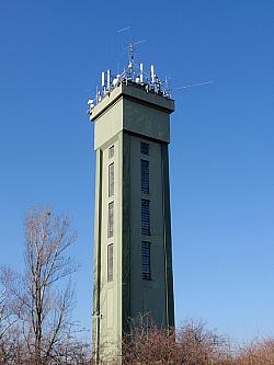
- route starts at the highest point of the town (by the waterworks above the railway track) and ends 1 km from railway station Jimlín
- trail has 5 stops: n.1 - Louny’s watersupply, n.2 –Climate, n.3 – Czech Middle Mountains, n.4 –Landscape pattern, n.5 - Soil science and sandy marl mining
- on the way back you can continue 1 km along the blue tourist sign; you will find a guidepost by the Jimlín railway station
- 2 km along the blue tourist sign you can see the castle Nový hrad (New castle)
- from Nový hrad (New castle) you can continue throught the chestnut alley to the cemetery, go further along the cemetery wall and rural road towards the west until you reach the road that leads to Líšťany or Louny
- more details can be found here
Louny’s water supply
The first mention of the development of the Louny drinking water distribution facility is from the 16th century, when the renaissance fountain was built in the square. Using the tunnel, the water was provided from Červený potok (Red Creek) that was running from Zeměchy to today’s puppet theater.
Already in the 18th century, Louny built its first water pipe supply system, and later completed it with several public fountains. The city built additional water pipes throughout the 19th century. A collecting tank that was built in 1900 did not meet the quality or capacity requirements of the city.
A high-quality well was built opposite the former city swimming pool in 1904. In the years 1932 and 1933 geological surveys of the surroundings were made and it lead to a solution to use the artesian water to fill the borehole opposite the swimming pool. It resulted in the increase in number of wells to nine and soon, the tenth – the main collection well – joined. Using centrifugal pumps, water was pumped from the main well into the terrestrial tanks and, later, into the 36m high water-tower that was handed over to the public in 1936.
Climate
According to E. Quitt, the Louny area is classified as a T2 warm weather area characterised by having a long, warm and dry summer, a warm spring and autumn with short transitional periods, and finally, a locally warm and dry winter with a very short duration of snow cover.
Czech Middle Mountains
The Czech Middle Mountains are part of the Podkrušnohoří regi
on.The landform occupies an area of 1265 square kilometers. Due to its unique relief and occurence of rare steppe and forest step communities, the major part of the Czech Middle Mountains is, today a protected landscape area of 1063 square kilometers. It can be subclassified into two units along the river Labe: Verneřice Middle Mountains - on the right bank - and Milešovice Middle Mountains on the left bank. The Czech Middle Mountains area is divided into 5 national nature preserves, 8 national natural monuments, 12 nature preserves and 18 nature monuments.
on.The landform occupies an area of 1265 square kilometers. Due to its unique relief and occurence of rare steppe and forest step communities, the major part of the Czech Middle Mountains is, today a protected landscape area of 1063 square kilometers. It can be subclassified into two units along the river Labe: Verneřice Middle Mountains - on the right bank - and Milešovice Middle Mountains on the left bank. The Czech Middle Mountains area is divided into 5 national nature preserves, 8 national natural monuments, 12 nature preserves and 18 nature monuments.
Landscape pattern
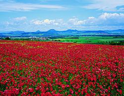
In the spring months, the scenery around the “ Dolní Poohří“ (Lower Ohře area) is affected by drying winds, which leads to wind erosion. The topsoil is carried away together with the drill.It leads to ongoing soil drift and accumulation, as during sand storms. There is a lack of natural vegetation due to the long-term impacts of agricultural activities in this area. The field is mostly used for growing wheat, rye, oats, barley, sunflower, canola and corn. As a result of use of modern weed-killers, a specific group of plants, characterized by remarkable resistance and resilience such as couch grass and thistle, can be found in this area.
Soil science and sandy marl mining
Since the soil is not the same everywhere, the track is divided by many characters. Brown humus on the sandy arenaceous marl is predominantly found in the local neighborhood. The biggest influence on the mineralogical composition of the local soil is sandy marlite, which was established by the stabilization of settled marls (a mixture of clay and limestone) with a secondary ingredient of sandy material. This soil is characterized by large amounts of bedrock stonechips in the top layer. Sandy marl, which represents the local bedrock, originates from the lower mesozoic era. The old sandy marl quarry was one of many used for mining of high-quality building stone. These quarries were established under the Austro-Hungarian mining act. It allowed everyone to have a quarry for their own use (a number of small quarries arose, you can find residue along the nature trail) and allowed owners to sell the building stone (an example, Kandera quarry, is approximately 100m south of this position).


