


Hiking
Tourist Routes - Hiking Routes

Nature trail Louny - Zeměchy
Route starts at the highest point of the town (by the waterworks above the railway track) and ends 1 km from railway station Jimlín
Route length: 3,12 km

Nature trail Louny - Lužerady
Leads through the northern part of Louny along the river Ohře, entire circuit consists of 4 stops
Route length: 5,5 km

Louny – Smolnice creek
Is located on the tourist path (yellow) leading from Louny along the garden city through Blšany hill, along Smolnice creek to Brloh, and either through Cítoliby or through field paths back to Louny
Route length: 2,5 km

Louny – walking trail Ohře
Short walk along the river Ohře from the Jirásek Mills to the Puppet theater. On three information panels you can find informations about the river Ohře, bank vegetation and ongoing constructions along the walking trail.
Route length: 1 km
")
Louny – Březno (Archeological open-air skanzen)
Walking (c. 45 min.) – from Louny square along the yellow tourist marker; in the direction from Postoloprty leave the Main Road (I) No. 7 for Březno municipality, then along the river
Route length: 6,5 km
")
Louny – Jimlín – Pravda (Pnětluky)
Walking (c. 20.5 km), from Louny (Mírové Square) along the red-marked path to Zbrašín (at the waterworks), from there along the blue-marked path as far as the parting of roads below Pravda
Route length: 20 km
")

Louny – Peruc
By bus (c. 20 min.), from Louny bus station (in the direction of Peruc)
Route length: 22 km
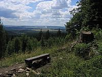
The national park Dzban
The region of high natural and recreational value.
Telephone: +420 313 575 114, +420 313 575 170E-mail: infocentrum@poddzbansko.cz, obec@mutejovice.czWWW: www.poddzbansko.cz
